 |
Northern Mine Research Society Registered Charity 326704 |
Collieries of the British Isles
The database behind this mapping arose from a much larger project, by Mike Gill, to establish a database of British Collieries. It began in 2003, partly in response to a suggestion by Alison Henesey, then librarian at the Yorkshire Coal Mining Museum, that "it would be useful to have a map which showed where the collieries were". Ten years later, the Northern Mine Research Society is proud to make this valuable tool freely available to anyone interested in coal mining history.
These maps are intended as tools for historians and they should not be used, in any way, to circumvent the process of Mining Reports and Property Search Services available from the Coal Authority. Anyone wishing to discover the likelihood of ground instability etc. should contact: The Coal Authority, 200 Lichfield Lane, Mansfield, Nottinghamshire, NG18 4RG, (Tel. 0845 762 6848).
Please note that sites are recorded as point data, but it must be remembered that some occupied large areas and may be associated with other industries.
Acknowledgements
No project like this can be completed without help from a wide range of individuals, and I would like to thank the following: G. Brooks, Dr I.J. Brown, P. Deakin, T. Knapp, H.M. Martell, Dr P. Murphy, D. Poyner, K. Ramsay, M.J. Shaw, I. Spensley, M. Street, L.O. Tyson, Dr R. Vernon
Especial thanks are due to: Matthew Town and Damien Ronan, of Northern Archaeological Associates Ltd, for converting files for use with Google Earth. Also, various librarians at the National Coal Mining Museum for England, and Ceri Thompson, Curator (Coal Collections) Big Pit at Blaenavon.
The project was also supported by a NMRS Grant towards the cost of data gathering.
The following sources have been used to compile the database:-
The maps are offered in both 2D format using Google Maps and 3D format; however you must have Google Earth installed on your computer to use this. The Google Earth files are slower to load and run than the 2D maps version, however both contain the same data. Point to and click on a marker to see details of that site.
These maps are intended as tools for historians and they should not be used, in any way, to circumvent the process of Mining Reports and Property Search Services available from the Coal Authority. Anyone wishing to discover the likelihood of ground instability etc. should contact: The Coal Authority, 200 Lichfield Lane, Mansfield, Nottinghamshire, NG18 4RG, (Tel. 0845 762 6848).
Please note that sites are recorded as point data, but it must be remembered that some occupied large areas and may be associated with other industries.
Acknowledgements
No project like this can be completed without help from a wide range of individuals, and I would like to thank the following: G. Brooks, Dr I.J. Brown, P. Deakin, T. Knapp, H.M. Martell, Dr P. Murphy, D. Poyner, K. Ramsay, M.J. Shaw, I. Spensley, M. Street, L.O. Tyson, Dr R. Vernon
Especial thanks are due to: Matthew Town and Damien Ronan, of Northern Archaeological Associates Ltd, for converting files for use with Google Earth. Also, various librarians at the National Coal Mining Museum for England, and Ceri Thompson, Curator (Coal Collections) Big Pit at Blaenavon.
The project was also supported by a NMRS Grant towards the cost of data gathering.
The following sources have been used to compile the database:-
- The Coal Authority
- The Coal Authority, Interactive Map Viewer
- The Coal Mining History Resource Centre
- Durham mapping
- Durham Mining Museum
- Envision Historic Mines (Ireland)
- Fife Pits
- Guide to the Coalfields (published by the Colliery Guardian)
- List of Mines 1854 to 1950 (Government report from the Mines Department)
- Museum of the Scottish Oil Shale Industry
- Ordnance Survey Ireland
- Ray Lawrence's "Coal Mining of ." Series of books on the South-Wales Coalfield
- Scottish Mining Website
- Welsh Coal Mines
- British Geological Survey Library at Keyworth
The maps are offered in both 2D format using Google Maps and 3D format; however you must have Google Earth installed on your computer to use this. The Google Earth files are slower to load and run than the 2D maps version, however both contain the same data. Point to and click on a marker to see details of that site.
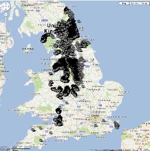
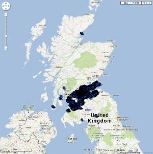
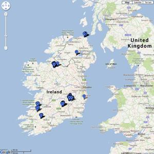
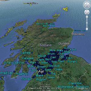
Maps version |
 |
 |
 |
 |
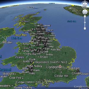
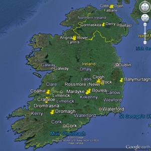
Earth version (slower) |
 |
 |
 |
 |
| ERRATA |
||
| Mine Name | Correct NGR | |
| Scotland | Andershaw | 282690.626060 |
| Scotland | Harwood | 301390.662010 |
| Scotland | Oakfield | 313330.693550 |
| Scotland | Whistleberry | 270230.657265 |
| Wales | Ainkell, Redbath & Bolton Hall | 191220.211350 |
| Wales | Eastern | 297075.194365 |
| Wales | Llanhilleth | 322045.200225 |
| Wales | New Duke | 269370.209255 |