GEOLOGY – An Overview
The coalfield in Leicestershire is centred upon the town of Ashby-de-la-Zouch although the town stands upon the Ashby anticline and there are no coal seams beneath it. This made it a popular place of residence in former years for the higher ranking colliery staff. The extent of the coalfield is from the south east fringe of Burton-on-Trent to a few miles west of the City of Leicester. In this generally north-west – south-east direction, the length of the coalfield is approximately 17 miles and its width approximately 9 miles. The coalfield is traversed and divided in a NNW-SSE direction by the Ashby anticline. To the west of the Ashby anticline and trending in the same direction is the Boothorpe Fault. Following a broadly similar route to the east of the Ashby anticline is the Thringstone Fault, which is a massive reversed fault with a maximum throw of over 2000 feet. This forms the eastern boundary of the coalfield.
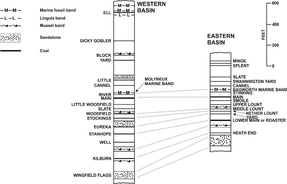
Fig 1 General Section of the Productive Measures
The part of the coalfield to the east of the Ashby anticline is generally known as the “Leicestershire Coalfield”. To the west of the Ashby anticline the northern part of the coalfield is traversed in a generally West to East direction by the Leicestershire – Derbyshire county boundary, and a significant section of this part of the coalfield is situated in the latter county. For this reason the part of the coalfield west of the Ashby anti-cline is generally known as the South Derbyshire coalfield. As both parts of the coalfield are roughly basin shaped they may also be referred to as the Eastern and Western Basins respectively. Only the coalfield or parts thereof which lie in the county of Leicester are dealt with in the following notes.
In the northern part of the coalfield, the coal measures are exposed, amounting to about 30% or slightly more of the whole area. To the south, and especially in the Leicestershire or Eastern Basin, the measures are overlain in a major unconformity by the New Red Sandstones. At Whitwick, in the Eastern Basin, and covering about 4 square miles of the surrounding area, is a thick igneous intrusion in the form of a sill, resting directly upon the coal measures. This intrusion is known as the Whitwick dolerite. The coal measures have been burnt by the intrusion but the overlying New Red Sandstones have not been affected. By inference, the intrusion pre-dates the laying down of the Red Measures and post-dates the laying down of the coal measures.
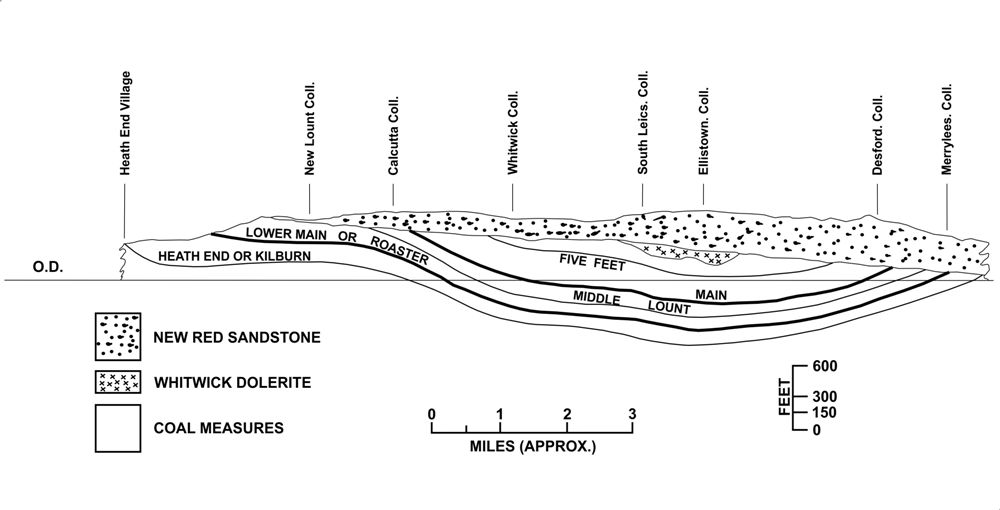
Fig 4 Section through Eastern Basin
East of the Thringstone Fault is an area of high ground known as the Charnwood Forest, and this area contains the oldest rocks in the general area. These rocks are of pre-Cambrian age and include slates, volcanic rocks and also other rocks of intrusive origin.
The Eastern Basin
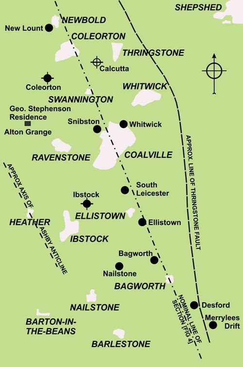
Fig 3 Collieries in the Eastern Basin
In the Eastern Basin of the coalfield, the New Red Sandstones (or Triassic) contain no major aquifers and presented few water problems to mining. This is in contrast to most areas of concealed coalfields where overlying New Red Sandstones can cause major water problems to mining activities. Working of coal seams nearer than 50 yards of the base of these measures was usually prohibited. This ruling was relaxed in the Leicestershire Eastern Basin and the unconformity was often exposed underground.
The lowest seam in the productive coal measures was the Heath End (or Kilburn). A short distance below this are the Wingfield Flags, a thick band of sandstone. The uppermost coals in the productive measures were worked to a sizeable extent near their outcrops with only a few at any depth. The Stinking Seam was sulphurous.
The first seam of importance was the Main Coal, generally five feet to seven feet in thickness. As the name implies this was the most important coal seam and was in general worked to exhaustion well before the cessation of mining in the coalfield. Below the Main Coal seam, what became important seams were the Upper, Middle and Nether Lount which were very widely worked latterly. Also at a slightly deeper level was the Yard seam (not to be confused with the Swannington Yard) which was a hard coal and was considerably worked latterly. Lying below these seams was the Lower Main or Roaster seam which again was a very important seam and worked largely to exhaustion before the general cessation of mining. The Roaster seam was in the order of 40 to 50 yards above the Heath End seam and was usually the lowest seam worked in the Eastern Basin. The thickness of the Roaster seam was generally about 8 feet.
In the Eastern Basin, the coal measures largely consisted of siltstones and mudstones with few sandstones. Faulting was also quite minimal. The dip of the measures was also quite moderate except in the vicinity of the Thringstone Fault where “drag” of the strata caused steep dips.
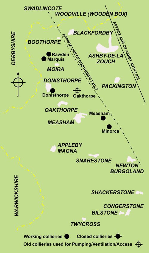
The Western Basin (or South Derbyshire)
 As in the Eastern Basin, the lowest coal seam in the South Derbyshire or Western Basin part of the coalfield was the Kilburn. About 200 feet below the Kilburn seam horizon is the thick sandstone known as the Wingfield Flags.
Straddling the Leicestershire – Derbyshire border at shallow depth were extensive clay deposits which were intensively worked and used in the manufacture of earthenware pipes, sanitary ware, bricks etc. These clays contained several quite thick coal seams of poor quality but were useful for firing the kilns used in the manufacture of earthenware goods.
Below these coal seams and the highest seam to be worked for general use was the Dicky Gobler of three to four feet in thickness. In descending sequence was the Little Coal seam and whilst seemingly neglected for a long time was considerably worked latterly as it contained “hards”. Before reaching the Main Coal was the Rider seam, which was a useful seam in the correlative sense. Its roof contained marine fossils which could be compared with the Bagworth band of marine fossils in the Eastern Basin.
The Main Coal seam, whose thickness varied from 12 feet to 16 feet was the most important seam in the Western Basin and was generally worked to exhaustion before the general cessation of coal mining in the area. Further down in the sequence were two seams which became important in the latter years of working in the coalfield, namely, the Woodfield and the Stockings. These two seams were very close together in many localities. The shale/ironstone roof of the Woodfield seam was rich in mussel fossils which closely compared with a similar bed in the roof of the Middle Lount seam in the Eastern Basin. Both the Woodfield and the Middle Lount also had a very thin clay-ironstone band about 9 inches below the roof.
Below the Stockings seam came the Eureka rock, a very hard and often thick sandstone, one of the few to be found in either the Eastern or the Western Basins. Immediately below the rock was the Eureka seam, a very important seam in the Western Basin and generally worked to exhaustion. In descending order the Eureka seam was followed by the Stanhope which was of considerable importance and very extensively worked. In many parts of the Western Basin and particularly in the southern part, the Stanhope was the lowest of the coal seams to be worked.
Faulting of the strata in the Western Basin is much more prevalent than in the Eastern Basin. In addition there are many smaller domes and basins within the general basin structure.
A small area of exposed coal measures in the generally concealed part of the coalfield was located at Heather, near Ibstock. This was the subject of many attempts at working from the late 18th Century for the next hundred years or so. The area proved difficult to work and none of the several pits sunk over the years had any real success. The seams remained largely unworked until the 1970’s when a large scale opencast mining project (Coalfield Farm) was initiated and proved to be successful.
Correlation
Correlation of the coal seams in the Eastern and Western Basins was hardly or never attempted for many years and the two parts of the coalfield went their separate ways in nomenclature. As was often the case in early coal mining, seams were named on a purely local basis and what later proved to be the same seam would have different names in different localities.
A very important geological report on the coalfields was made by Fox-Strangeways in 1907 but the differences in the naming of the seams between the Eastern and Western Basins remained largely the same. A further report was made in the 1940’s by Mitchell and Stubblefield and this was followed in the 1960’s by extensive work in correlation carried out by J. Spink. However, the nomenclature used in the foregoing notes is that which was in general use in the 1950’s.
Water
A study of the effect of the ceasing in pumping in the Eastern Basin following the closure of the last of the deep mines in 1991 in the Eastern Basin was made by J.A. Smith and J.J. Colls. This work was published in 1996 in the Journal of the Chartered Institution of Water and Environmental Management under the title “Groundwater Rebound in the Leicestershire Coalfield”.
Average annual rainfall in Leicestershire was stated to be approximately 26.3 inches with a mean evaporation of about 19 inches. This left the low figure of just under 7½ inches for run-off and infiltration. With few sandstones to absorb rainwater it was estimated that infiltration into undisturbed coal measures could be as low as 1 inch per annum.
In the exposed coalfield however, the ground had been greatly disturbed by hundreds of years of mining. This mining was by a combination of shallow pits, pillar and stall and very early longwall methods. Calculations estimated that infiltration into the exposed coal measures could be as high as 4½ inches per annum or thereabouts. This amount of infiltration into old workings illustrates the need for large pumping machinery to protect newer workings down dip.
Observation of pumping regimes revealed that in the concealed coal measures pumping in any given year reflected the rainfall of the previous year. In the exposed part of the coalfield, pumping reflected the same year’s rainfall.
Coal Characteristics
In both parts of the coalfield the coals were very similar. Most coals were “brights” with quite a low ash content of 2% (very low), to 8%. Volatiles were high at 38% to 45% and moisture was 13% to 17%. Sulphur content varied from 1% to 3% and chlorine 0.05% to 0.3%.
The Main, Roaster and Stockings seams and also the Yard, contained bands of hard dull coal, known locally as “spires”. The spires were suitable as railway locomotive coals. The free burning characteristics of the “brights” made them popular for household use, especially in London and the South East of England.
The coals were generally liable to spontaneous combustion.
Copyright © NMRS Records: Geoff Hayes Collection
Return to previous page
