The database behind this mapping arose from a much larger project by Mike Gill to establish a database of British Collieries. It began in 2003, partly in response to a suggestion by Alison Henesey, then librarian at the Yorkshire Coal Mining Museum, that “it would be useful to have a map which showed where the collieries were”. Ten years later, the Northern Mine Research Society made this valuable tool freely available to anyone interested in coal mining history. The mapping underwent a major update in May 2018.
These maps are intended as tools for historians, and they should not be used in any way to circumvent the process of Mining Reports and Property Search Services available from the Coal Authority. Anyone wishing to discover the likelihood of ground instability, etc. should contact: The Coal Authority, 200 Lichfield Lane, Mansfield, Nottinghamshire, NG18 4RG, (Tel. 0845 762 6848).
Please note that sites are recorded as point data, but it must be remembered that some occupied large areas and may be associated with other industries.
We also have other maps covering mining, and these can be found here
Acknowledgements
No project like this can be undertaken without help from a wide range of individuals, and I would like to thank the following: D. Barker, G. Brooks, S. Brooks, Dr I.J. Brown, D. Cameron, P. Cullen, P. Deakin, S. Grudgings, D. Hardwick, D. Kitching, T. Knapp, R. Lynch, H.M. Martell, R. Matthews, A. Moyes, Dr P. Murphy, S. O’Brien, D. Poyner, K. Ramsay, C. Seal, M.J. Shaw, I. Spensley, P. Sproat, M. Street, L. Turnbull, L.O. Tyson, Dr R. Vernon, M. Wilson, T. Woods.
Special thanks are due to Theodore Faull, Head of GIS at Terrafirma Mine Searches Ltd., for converting files for use with Google Maps. Also, various librarians at the National Coal Mining Museum for England, and Ceri Thompson, Curator (Coal Collections), Big Pit at Blaenavon.
The project was also supported by an NMRS Grant towards the cost of data gathering.
The following sources have been used to compile the database:-
- The Coal Authority
- The Coal Authority, Interactive Map Viewer
- Durham Mining Museum
- Envision Historic Mines (Ireland)
- Fife Pits
- Museum of the Scottish Oil Shale Industry
- National Library of Scotland – Geo-referenced maps
- National Library of Scotland – Maps by place
- Northern Ireland, Abandonment Plans
- Ordnance Survey Ireland
- Oswestry Borderland Heritage
- PRONI Historical Maps viewer
- Scottish Mining Website
- Shropshire Collieries
- British Geological Survey Library at Keyworth
Books
- Guide to the Coalfields (1947 – 1993)
- International Guide to the Coalfields
- Lawrence, Ray “Coal Mining of ….” Series of books on the South Wales Coalfield.
- List of Mines in the United Kingdom of Great Britain etc, 1854 to 1950.
- Shaw, M. (2016). The Mines of the Shrewsbury Coalfields (You Caxton Publications)
- Turnbull, L. (2016) The World of William Brown: Railways, Steam Engines, Coalmines (Newcastle: North of England Institute of Mining & Mechanical Engineers)
- Turnbull, L. (2017). The Early Railways of the Derwent Valley (Newcastle: North of England Institute of Mining & Mechanical Engineers)
Thanks are also due to the following, who have commented on the original mapping:-
Derek Barker and Tony Woods for comments on locations in the Heaton and Shipley areas of Bradford.
- Simon Brooks (NEIMME) for comments on mines around Newcastle upon Tyne.
- Don Cameron (BGS) for comments on mines around Kelty, in Fife.
- Phil Cullen, author of ‘Gwendraeth Valley Coal Mines’, published in 2010, has kindly helped with comments and corrections for that area.
- Steve Grudgings and David Hardwick for the collieries around Bristol and Yate.
- Roger Lynch for collieries south of the River Calder in Yorkshire.
- David Kitching for corrections and additional data on the Cheshire mines.
- Richard Matthews for details of pits comprising the Altham and Dunkirk collieries in north-east Lancashire.
- Stephen O’Brien for the location of Fishescoats Colliery at Rutherglen.
- Clive Seal for help with the Alston area collieries.
- Paul Sproat for tweaking and adding sites around Blyth.
- Les Turnbull for help with early collieries within the Newcastle upon Tyne area. See also below for his excellent studies of early colliery engines and railways in the same region.
Historical data for the period 1854 to 1950 comes from the ‘‘List of Mines in the United Kingdom of Great Britain etc’.
Historical data for the period 1947 to 2000 comes from the ‘Guide to the Coalfields’ and the ‘International Guide to the Coalfields’ and is published with the permission of the Colliery Guardian.
Copies of these were perused at the following libraries:-
- British Geological Survey, at Keyworth
- British Library, at Boston Spa
- National Coal Mining Museum (England), at Caphouse Colliery
- Science Museum Library, in Manchester
The maps are displayed using Google Maps. Click on a map to open it, then point to and click on a marker to see details of that site.
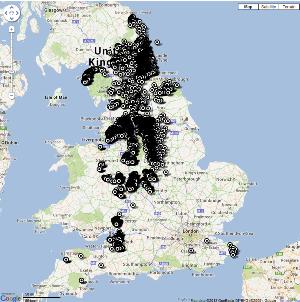
England
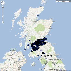
Scotland
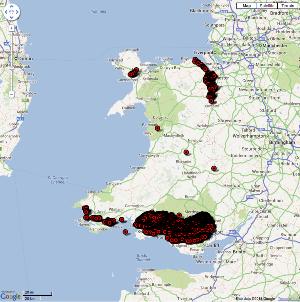
Wales
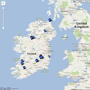
Ireland
| ERRATA | ||
| Mine Name | Correct NGR | |
| Scotland | Easthouse Pit | 334515.665500 |
| Scotland | Minivie | 246510.607439 |
| Scotland | Schaw | 244563.620570 |
| Scotland | Shotlinn | 270748.649024 |
| England | Cinder Ovens | 415869.438279 |
| England | Greengates | 418476.437238 |
| England | Hartley, Hester Pit | 431108.576718 |
| England | Head o’th’ Lane | 384971.353700 |
| Wales | Rhiw Goch | 305665.267853 |
| [In correct place, but shown as a coal shaft on OS = unlikely] | ||
