The database behind this mapping began life as a paper index of sites in the Northern Cavern & Mine Research Society Records in the early 1960s. It was digitised, in dBASE III format, in the late 1980s and is now held in Access and contains a wide range of information. The Northern Mine Research Society is pleased to make this valuable tool freely available to anyone interested in mining history.
Please note that sites are recorded as point data, but it must be remembered that some occupied larger areas.
Mike Gill – NMRS Recorder
We also have other maps covering mining and these can be found here
Acknowledgements
No project like this can be completed without help from a wide range of individuals, and over fifty years many people have contributed data, much of it from NMRS publications. Nevertheless, I would like to thank Ian Spensley and Les Tyson for sharing their extensive work on the northern Yorkshire Dales, and John Ambler for sites in Cornwall and the Weald.
Especial thanks are due to: Theodore Faull, Head of GIS at Terrafirma Mine Searches Ltd., for converting files for use with Google Maps.
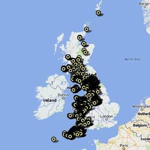
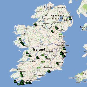
The maps are displayed using Google Maps, click on a map to open it, then point to and click on a marker to see details of that site.
Google have moved the goalposts again, and the maps are reporting as not working. However, if you click the OK button, the mapping still works, although the satellite function is no longer available. This will be corrected when I get time.
England
Ireland
| ERRATA | ||
| Mine Name | Correct NGR | |
| England | Abraham Consols | 163115.33735 |
| England | Advent Moor | 212840.83272 |
| England | Pim Hill | 348805.321430 |
| England | St Cadix Smelting House | 213447.54592 |
| Ireland | Conlig | 749125.876680 |
| Ireland | Glencarbury | 573150.845265 |
| Ireland | Hollyford | 593335.654090 |
| Ireland | Monaghan | 677695.823745 |
