This is an interactive map, please point to and click on an area to see greater detail
See also online mapping of our database of over 23,000 Collieries of the British Isles.
See also Jet Mining
Out of 1503 collieries in operation at the time of nationalisation in 1947, now there are none left. The last, Kellingley Colliery at Knottingley in Yorkshire, closed in 2015.
General pages on Coal Mining
1984 Strike
1984 Strike at Celynen South Colliery
A coal miners’ life in the 1970s
A Visit to a Pit – 23rd January 1879
Accidents & Disasters, mainly in Coal Mines
Coalface Supports in the 1970s
Davy Safety Lamps
Life at Middleton Colliery Leeds in the 1950s
Life in a Welsh colliery in the 1940s
Working at Penallta Colliery in 1933
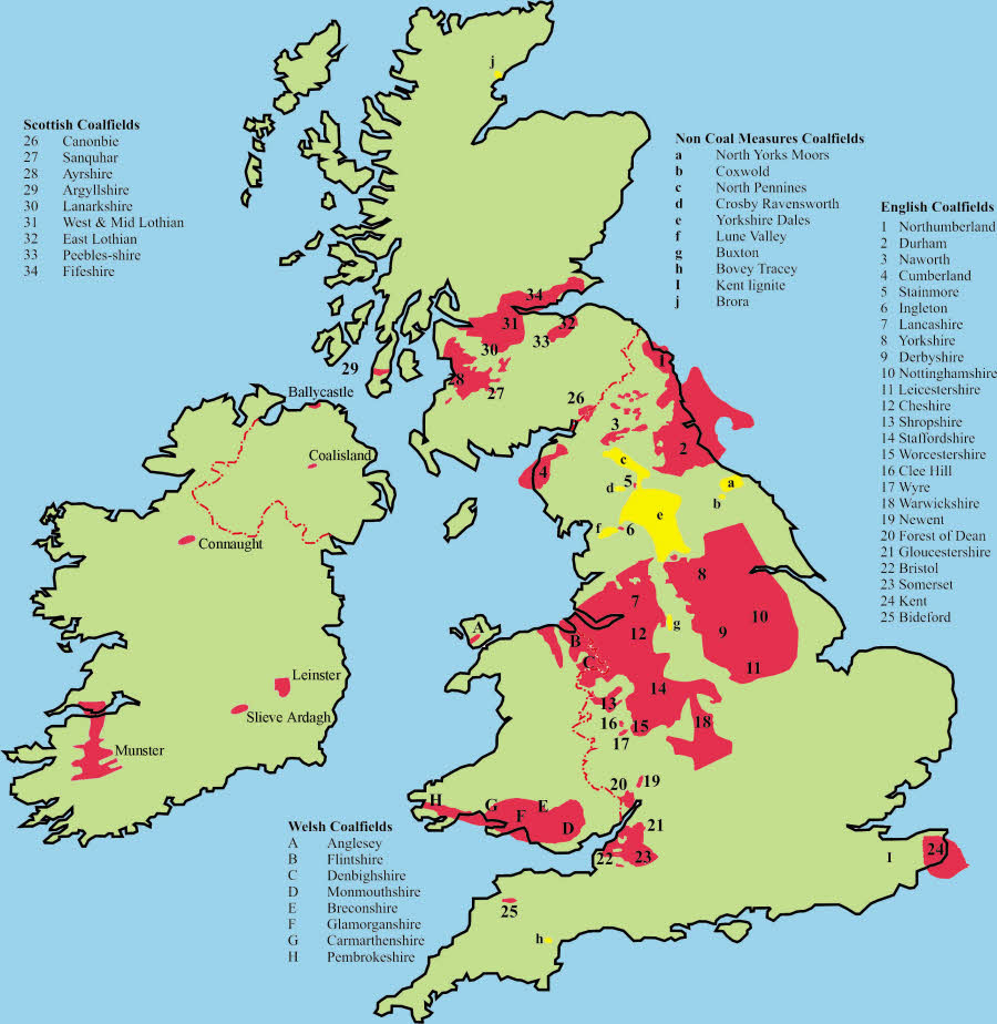
Coal Bearing Rocks in the British Isles
As the name suggests, most coal came from rocks historically known at the Coal Measures, but now called Westphalian. Coal was also formed in other geological periods, and our ancestors took advantage of this to work very thin seams for fuel.
| Geological Stage | From | To | Area Found | |
|---|---|---|---|---|
| Mya (million years ago) | ||||
| Neogene (Lower Miocene epoch) | 23 | 16 | Devon (lignite) | |
| Cretaceous | 145 | 65 | Kent (lignite) | |
| Bajocian (Mid Jurassic epoch) | 172 | 167 | Cleveland and Caithness | |
| Westphalian (Coal Measures) | 314 | 306 | Extensive | |
| Namurian | 327 | 313 | Mid and North Pennines | |
| Brigantian | 330 | 326 | Mid Pennines | |
A detailed, five volume economic history of the British coal industry was published between 1985 and 1993 by the Clarendon Press.1-5 Since that date, however, the industry has been privatised and survives in a very reduced size. For many, a more accessible study of the industry’s chronology is given by Alan Hill.6
Coal Geology
Most English coal deposits, traditionally referred to as the Coal Measures, were laid down during the Westphalian regional stage of the Carboniferous period when, between 313.5 and 306.5 Mya (million years ago), extensive freshwater swamps sometimes flourished on deltas or behind coastal barriers at tropical latitudes.7 There are also the Culm measures of north Devon which are problematic in age, but are probably Westphalian. They are anthracitic in nature and were probably formed on the margin of the main delta.
The sediments were predominantly sands, silts and mudstones, but where they broke water’s the surface peat accumulated in swamps, which rotted under anoxic conditions and eventually formed coal. It is estimated that it took the peat approximately 10,000 years to reach a thickness of ten metres; enough to make around one metre of coal. These deltaic areas subsided slowly (from 1 to 5 mm per year) as, under their increasing weight, the sediments became compressed.
The rate of subsidence was often equal to the rate that sediments accumulated, but occasionally the process was interrupted. Commonly, the process of peat formation would be ended by the deposition of mud. However, tectonic activity could also cause the landmass, which provided the source material for the deltas, to be uplifted at a faster rate. Such an event would increase the rate of erosion on the land and permit the deposition of sand or grit in the deltaic area. Sediment would cover the peat, and the peat was often eroded by the changing river patterns. More rarely, an increase in the rate that the delta subsided could result in a marine incursion. Marine bands that result from such incursions as a rule usually form the roof of coal seams, and are useful for correlation purposes.
Generally, the cycle of deposition followed a set sequence. The peat would be covered by mud grading upwards into sand. Eventually vegetation would become established in the semi-submerged sand, which would then be invaded by roots, to form a seatearth, or fireclay, on which the peat would accumulate. This characteristic sequence of deposition is known as a cyclothem. This cycle of swamp-subsidence-flooding-sediment infill-swamp was repeated many times over, which is why coalfields usually have a sequence of coal seams, and may reach a total thickness of hundreds of metres, even though all the sediments were deposited in shallow water.
Faulting also affected deposition. The slow movement of basement faulting beneath the deltas could cause variations in sedimentation. If these ancient faults remained active, it led to differential rates of subsidence on either side of them. While sediments might continue to accumulate on one side, therefore, on the other they might become flooded and covered with sediment until a new swamp forms. Thus what had been a thick seam might appear to split into two or more thinner ones. This process could also happen where surfaces subsided differentially for other reasons, but it always had a profound effect on the layout of mines and their workings.8
The coal fields in central and northern England were uplifted when the Pennines formed and, except for small outliers left by major faults (e.g. the Ingleton and Sleightholme coalfields), those areas have eroded to reveal the core of older rocks. Subsequent ground movements caused further, localised uplift, tilting, buckling and fracturing of the strata. Again, these effects are major determinators of a mine’s layout. In particular, it meant that seams outcropped, allowing early miners to find them and work them from drifts or shallow shafts, before progressing to deeper, concealed coal. Of all Britain’s coalfields only Kent’s does not outcrop. Its presence was realised by extrapolating French geology westward and it was then discovered by boreholes.
Older coal seams, in Brigantian (330 to 326.4 Mya) and Namurian (326.4 to 313.5 Mya) strata, were also worked.9,10 Although generally quite thin, these seams were of considerable local importance for lime burning and domestic fuel. Sometimes their coal was cokeable, which added value. The Namurian seams in particular were formed on an active paleo-surface of river channels, sand banks, flood plains and lagoons, in which coal swamps formed on sand or mud substrates. It is possible, therefore, for seams to be broadly coeval, but not necessarily conjoined. Periodic incursions of sediment-rich water into the lagoons from river channels, or sea, caused the high ash content common to such seams.
Younger coals have also been worked in Bajocian age rocks of the Mid Jurassic epoch, dating from 171.6 to 167.7 Mya, on the North Yorkshire Moors.11 Unlike the Carboniferous-age coals, these Permian-Jurassic coalfields originated in temperate latitudes. Small deposits of lignite, an even younger, soft brown coal, found in Chalk (145 and 65 Mya), were worked at Cobham in Kent. Lignite was also worked around Bovey Tracey in Devon.12 It formed in the Lower Miocene epoch, of the Neogene Period, and dates from between 23 and 15.9 Mya.
As well as coal, the Carboniferous Coal Measures supported a range of extractive industries. These included clay for brick making, sandstones which were quarried for building stone, and the seatearths for fireclay and ganister. Clay ironstones were also locally important. They were formed in the reducing conditions within the freshwater swamps where iron went readily into solution. When oxidized the iron would precipitate and combine with carbonates to form sideritic mudstone. Some iron-rich horizons formed thick ironstones that were economically important, like those in the West Midlands or the Tankersley Ironstone of Yorkshire, for example.13,14 Ironstone could occur in beds, as nodules or, less often, impregnated sandstone. Iron also combined with sulphur, which was freely available in swamps, to form iron pyrites (FeS4), which occurs as nodules in some seams and was used for making copperas (FeSO4.7H2O). Sulphur was also a major pollutant in some coals.
- Hatcher, J. The History of the British Coal Industry: Vol.1 – Before 1700 (Oxford: Clarendon Press, 1993)
- Flinn, M.W. The History of the British Coal Industry: Vol.2 – 1700-1830 The Industrial Revolution (Oxford: Clarendon Press, 1985)
- Church, R. The History of the British Coal Industry: Vol.3 – 1830-1913 Victorian Pre-eminence (Oxford: Clarendon Press, 1986)
- Supple, B. The History of the British Coal Industry: Vol.4 – 1913-1946 The Political Economy of Decline (Oxford: Clarendon Press, 1987)
- Ashworth, W. The History of the British Coal Industry: Vol.5 – 1946-82 The Nationalized Industry (Oxford: Clarendon Press, 1986)
- Hill, A. Coal – A Chronology For Britain, British Mining No.94, 2002
- www.bgs.ac.uk/education/britstrat/carboniferous.html
- Williamson, I.A. 1999 “The Burnley Coalfield: Some geological influences upon the former mining exploitation and present-day development” British Mining No.63, pp.5-27
- Gill, M.C. 2008 “Great Dales Coalfield, Eastern Areas” British Mining No.86, pp.68-108
- www.bgs.ac.uk/education/britstrat/jurassic.html
- Gill, M.C. 2010 “The North Yorkshire Moors Coalfields (Yorkshire’s Other Forgotten Coalfields)” PDMHS Mining History, Vol.17 No.6 Winter, pp.19-31
- Pengelly, W. & Heer, O. 1863 “On the lignite formation of Bovey Tracey, Devonshire” London: Taylor & Francis. (From Philosophical Transactions, Part 2, 1862, pp.1-68, plates i-xx
- Raistrick, A. 1939 “The South Yorkshire iron industry 1698-1756” Transactions Newcomen Society, 1938-39, No.19. pp.51-86
- Hemingway, J.E. 1974 “Ironstone” In Rayner and Hemingway. The Geology and Mineral Resources of Yorkshire. Yorkshire Geological Society. pp329-331
